Understanding the Water Cycle

The earth has a limited amount of water.  That water keeps going around and around and around and around and in what we call the “Water Cycle”.

This cycle is made up of a few main parts:

  • evaporation (and transpiration)
  • condensation
  • precipitation
  • collection

1.Evaporation is when the sun heats up water in rivers or lakes or the ocean and turns it into vapor or steam. The water vapor or steam leaves the river, lake or ocean and goes into the air.

2.Condensation: Water vapor in the air gets cold and changes back into liquid, forming clouds. This is called condensation.

You can see the same sort of thing at home… pour a glass of cold water on a hot day and watch what happens.  Water forms on the outside of the glass.  That water didn’t somehow leak through the glass!  It actually came from the air.  Water vapor in the warm air, turns back into liquid when it touches the cold glass.

3.Precipitation occurs when so much water has condensed that the air cannot hold it anymore.  The clouds get heavy and water falls back to the earth in the form of rain, hail, sleet or snow.

4.Collection:  When water falls back to earth as precipitation, it may fall back in the oceans, lakes or rivers or it may end up on land.  When it ends up on land, it will either soak into the earth and become part of the “ground water” that plants and animals use to drink or it may run over the soil and collect in the oceans, lakes or rivers where the cycle starts ALL OVER AGAIN! MORE

Which Human Activities Pollute The Atmosphere?

  • Cars
  • Leaving lights on
  • the televison
  • the computer
  • plantations
  • dust
  • Noise pollution (sounds of factories running)
  • smoking
  • Not recycling

How Can Pollution effect us?

The extent to which an individual is harmed by air pollution usually depends on the total exposure to the damaging chemicals, i.e., the duration of exposure and the concentration of the chemicals must be taken into account. Examples of short-term effects include irritation to the eyes, nose and throat, and upper respiratory infections such as bronchitis and pneumonia. Other symptoms can include headaches, nausea, and allergic reactions. Short-term air pollution can aggravate the medical conditions of individuals with asthma and emphysema. In the great “Smog Disaster” in London in 1952, four thousand people died in a few days due to the high concentrations of pollution.

Long-term health effects can include chronic respiratory disease, lung cancer, heart disease, and even damage to the brain, nerves, liver, or kidneys. Continual exposure to air pollution affects the lungs of growing children and may aggravate or complicate medical conditions in the elderly. It is estimated that half a million people die prematurely every year in the United States as a result of smoking cigarettes.

What is Acid Rain?

Acid rain is rain, snow or fog that is polluted by acid in the atmosphere and damages the environment. Two common air pollutants acidify rain: sulphur dioxide and nitrogen oxide. When these substances are released into the atmosphere, they can be carried over long distances by prevailing winds before returning to earth as acidic rain, snow, fog or dust. When the environment cannot neutralize the acid being deposited, damage occurs.
Flow chart showing dry and wet deposition processes. If you have difficulty viewing this graphic, or need additional information, contact Cindy Walke, Web Manager, at 202-343-9194.

Cloud Mania

Cirrus clouds

are the most common of the high clouds. They are composed of ice and are thin, wispy clouds blown in high winds into long streamers. Cirrus clouds are usually white and predict fair to pleasant weather. By watching the movement of cirrus clouds you can tell from which direction weather is approaching. When you see cirrus clouds, it usually indicates that a change in the weather will occur within 24 hours.


Cirrostratus clouds

are thin, sheetlike high clouds that often cover the entire sky. They are so thin that the sun and moon can be seen through them. Cirrostratus clouds usually come 12-24 hours before a rain or snow storm.
 

Cirrostratus clouds

are thin, sheetlike high clouds that often cover the entire sky. They are so thin that the sun and moon can be seen through them. Cirrostratus clouds usually come 12-24 hours before a rain or snow storm.
 

Altostratus clouds

 are gray or blue-gray mid level clouds composed of ice crystals and water droplets. The clouds usually cover the entire sky. In the thinner areas of the clouds, the sun may be dimly visible as a round disk. Altostratus clouds often form ahead of storms with continuous rain or snow.

Altocumulus clouds

are mid level clouds that are made of water droplets and appear as gray puffy masses. They usually form in groups. If you see altocumulus clouds on a warm, sticky morning, be prepared to see thunderstorms late in the afternoon.

Stratus clouds

are uniform grayish clouds that often cover the entire sky. They resemble fog that doesn’t reach the ground. Light mist or drizzle sometimes falls out of these clouds.

Stratocumulus clouds

 are low, puffy and gray. Most form in rows with blue sky visible in between them. Rain rarely occurs with stratocumulus clouds, however, they can turn into nimbostratus clouds.
Nimbostratus clouds form a dark gray, wet looking cloudy layer associated with continuously falling rain or snow. They often produce precipitation that is usually light to moderate.

Cumulus clouds

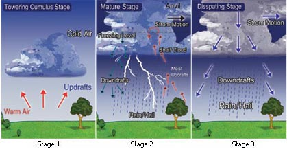
are white, puffy clouds that look like pieces of floating cotton. Cumulus clouds are often called “fair-weather clouds”. The base of each cloud is flat and the top of each cloud has rounded towers. When the top of the cumulus clouds resemble the head of a cauliflower, it is called cumulus congestus or towering cumulus. These clouds grow upward and they can develop into giant cumulonimbus clouds, which are thunderstorm clouds.

Cumulonimbus clouds

are thunderstorm clouds. High winds can flatten the top of the cloud into an anvil-like shape. Cumulonimbus clouds are associated with heavy rain, snow, hail, lightning and even tornadoes. The anvil usually points in the direction the storm is moving.
CloudCloud ChartCloud

Cloud Group Cloud Height Cloud Types
High Clouds = Cirrus Above 18,000 feet Cirrus
Cirrostratus
Cirrocumulus
Middle Clouds = Alto 6,500 feet to 18,000 feet Altostratus
Altocumulus
Low Clouds = Stratus Up to 6,500 feet Stratus
Stratocumulus
Nimbostratus
Clouds with Vertical Growth Cumulus
Cumulonimbus
Special Clouds Mammatus
Lenticular
Fog
Contrails

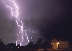
What Causes Lightning?

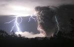
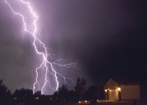
Lightning is an electric current. Within a thundercloud way up in the sky, many small bits of ice (frozen raindrops) bump into each other as they move around in the air. All of those collisions create an electric charge. After a while, the whole cloud fills up with electrical charges. The positive charges or protons form at the top of the cloud and the negative charges or electrons form at the bottom of the cloud. Since opposites attract, that causes a positive charge to build up on the ground beneath the cloud.

The grounds electrical charge concentrates around anything that sticks up, such as mountains, people, or single trees. The charge coming up from these points eventually connects with a charge reaching down from the clouds and – zap – lightning strikes!

How Does Hail Form?

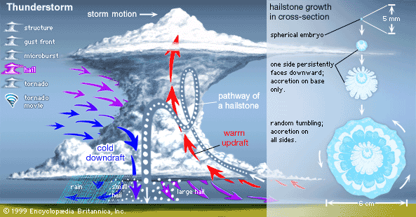
Hail stones start as water drops. A strong wind updraft blows the drops up above the freezing level in the clouds and the drops freeze. When they get heavy enough, they fall. When they fall, one of three things can happen; the hail stone will melt and fall as rain, the hail stone won’t melt and will fall as a hail stone or the updraft will be strong enough to blow the hailstone back above the freezing level and the stone will get bigger.

What Causes Wind?

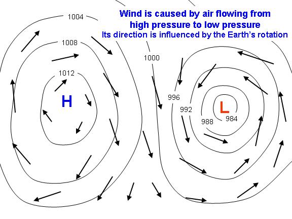
Wind is caused by air flowing from high pressure to low pressure. Since the Earth is rotating, however, the air does not flow directly from high to low pressure, but it is deflected to the right (in the Northern Hemisphere; to the left in the Southern Hemisphere), so that the wind flows around the high and low pressure areas. This effect of the wind “feeling the Earth turn underneath it” is important for very large and long-lived pressure systems. For small, short-lived systems (such as in the cold outflow of a thunderstorm) the wind will flow directly from high pressure to low pressure.

Why Does it Rain?

When clouds develop or rain occurs, something is making the air rise. Several things can make this happen. Mountains, low-pressure areas, cold fronts, and even the jet stream

High Pressure and Low Pressuer systems

High Pressure System

Often, you hear a weather forecaster say that an area of high pressure will dominate the weather. This usually means your region has several partly to mostly sunny days in store with little or no precipitation. Air tends to sink near high-pressure centers, which inhibits precipitation and cloud formation. This is why high-pressure systems tend to bring bright, sunny days with calm weather. Air flows clockwise around a high-pressure system in the northern hemisphere. As a result, regions to the east of a high-pressure center often have northerly winds bringing in relatively cold air while regions to the west have southerly winds bringing in relatively warm air. Sometimes, high-pressure systems stall over a particular region for long periods of time and bring several days of sunny, calm weather with little or no precipitation. High pressure systems usually form where the air converges aloft. As the air converges in the upper-levels of the atmosphere, it forms an area of higher pressure and is forced to sink. The sinking air spirals outward, clockwise in the Northern Hemisphere, counterclockwise south of the Equator. High pressure systems are steered by upper-level winds much the same way low pressure systems are steered.

Low Pressure System

This usually means cloudy weather and precipitation are on the way Low pressure systems have different intensities with some producing a gentle rain while others produce hurricane force winds and a massive deluge. The centers of all storms are areas of low air pressure.

Relating to..

Good weather: High Pressure System

Poor weather: Low Pressure System

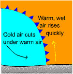
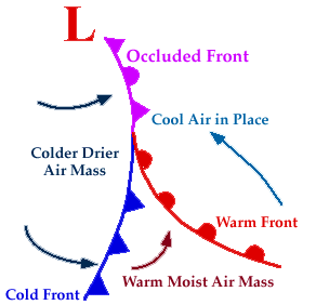
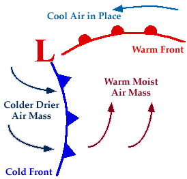
Warm air catching the cold front


Cold air catching warm front


Weather Watch Vs. Weather Warning

Weather Watch

A forecast issued by the National Weather Service indicating that conditions are favorable for a particular weather hazard.

Weather Warning

A forecast issued by the National Weather Service indicating that a specific weather event is actually occurring.